
Photographer William Henry Jackson walked behind Kin Kletso and clambered up Chaco Canyon’s North Mesa in 1877. He named previously-overlooked Pueblo Alto for its lofty location up there. The ruin commands panoramic views of the San Juan Mountains and Huerfano Mesa (north), the volcanic cone of Mount Taylor (south), the eroded thumb of Fajada Butte (east) and the Chuska Mountains to the west in Arizona – on a clear day.

Pueblo New Alto from North Mesa Trail
Pueblo Alto is thought to have been a commercial trading center for Chaco, from all the turquoise beads and other artifacts found there. It may have been used as a signal station to a network of Chaco outliers. It also marked the start of the Great North Road towards Salmon Ruin 70 miles away.
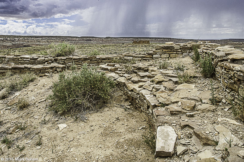
Pueblo Alto and view of New Alto
Careful excavation works as a research tool, but it’s hard on long-term stability. So Thomas Windes’ 1976-78 excavation of Pueblo Alto backfilled rooms to keep them from collapsing over time. His results give us one of the most recent interpretations of Alto’s likely use and residency.
Chaco’s attractions require you to pick and choose – trust me, you can’t see it all in a day. If you try, you end up cramming things in. On other visits in winter, I’ve had to speed-hike North Mesa’s Pueblo Alto loop to get back to my car at sunset after a mid-afternoon start.
So this time, I dedicated my Chaco visit to just hiking that loop. We were also looking for the Great North Road.
Getting up on North Mesa is a challenging scramble through a rockfall and narrow crack behind Kin Kletso. Once you’re up there, it’s easy to follow the ducks and occasional signs. We were hiking on an unusually comfortable June day, with intermittent thunderstorms and temperatures 10 to 15 degrees below normal. As storms cleared out, we got skies so blue you wanted to pinch them to be sure they were real.
Pueblo Alto has the usual “block of 5-6 rooms plus small kiva” plan of later Great Houses, with several room blocks placed together in the classic D-shape. You know there are backfilled or unexcavated ruins and trash below the mounds you see, and a few walls are visible. A free-standing east-west wall connects Pueblo Alto with New Alto, the most visible ruin on North Mesa. You can walk through rooms and look at the later McElmo-style masonry there.
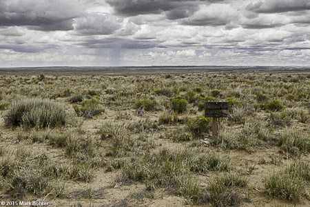
Great North Road starts at the sign
The connecting wall between Old and New Alto is partially buried but visible, but you need the sign to find the start of the Great North Road. It was verified by aerial and satellite photography in visible light and infrared, so I didn’t feel too bad. It’s overgrown by sage and prickly pear.
We continued hiking to the Jackson Stairs. The bottom of this pre-Columbian stairway has fallen out, and the remaining steep steps carved into the mesa’s wall would make me think twice about ever wanting to go that way.
Past the Stairs, you descend partway through a one-foot wide crack in the sandstone. Walk along the lower bench that follows and you’ll see Chetro Ketl and the notch between South and Chacra Mesas. I used a 24mm f/3.5L TS-E lens to horizontally shift Chetro Ketl’s back wall entirely into my picture. This avoided me having to step into space to capture the shot.
There’s also an overlook of Pueblo Bonito and the now-fallen Threatening Rock.
We both ran out of water around 1 1/2 miles before the end of the loop. There were some water-filled tinajas in the sandstone, but in a normally-dry June, you can’t count on them. Next time, I’ll bring at least a couple quarts.
Mark,
Great photos and text of a place I love dearly! I was happy to find your blog post and photography site. When in June was your visit? Looks like you missed Solstice, as did I this year (darn!). Great that you avoided the normal brutally hot June weather.
I always love the lighting when it is stormy – you captured it nicely in some of your shots. I see from your photo web site that you’ve been several times over the years. Always love connecting with others who love Chaco!
Chaco cheers!
Christina
Christina:
Thanks for your praise. My fiancee and I were at Chaco on June 24. My goal was finding the Great North Road where it starts at Pueblo Alto and we both wanted to hike and photograph, so we didn’t look for solstice markers and alignments.
The San Francisco Bay Area has very boring summer weather – monotonous blue skies with no clouds. So I usually forget about photographing anything interesting outside for the summer.
I love being out with a camera in a storm, and my EOS 1D mark II and Canon L-series lenses are almost waterproof. I captured some images of mule deer feeding in the rain at Rancho San Antonio, and elephant seals ignoring the rain at Ano Neuvo. Most wild mammals will shake off water just like a domestic dog. This includes sea otters when they leave the water.
Thanks again. Maybe I’ll see you at Chaco some time!
Mark
With havin so much content do you ever run into any issues of plagorism or copyright violation? My website has a lot of exclusive content I’ve either authored myself or outsourced but it seems a lot of it is popping it up all over the web without my permission. Do you know any techniques to help stop content from being ripped off? I’d really appreciate it.
Copyright-watermark all your pictures, and write about unique topics in your own words with your own ideas. Avoid paraphrasing or cribbing someone else’s work. Register copyrighted material with the U.S. copyright office, or your country’s equivalent. Go after thieves of your copyrighted material, especially photographs.
Those are the best tips.